Saturday, October 17, 2015

Cumberland Falls, Eagle Falls, and Sanders Cafe


Cumberland Falls, Eagle Falls and Sanders Café

Corbin, KY

Morehead Outdoors


I may have to work this Saturday and miss the Court Days Festival in Mt. Sterling, KY but the upside is that I get a full day off during the week. I've always got a couple of road trips up my sleeve for just such an occasion. I weighed out my options and decided to travel to the Cumberland Falls State Park. I checked the weather the night before. Sunny and a high of 70 degrees. The bad news is when I left that morning it was about 40 degrees. It normally wouldn't matter but today's road trip will be on my motorcycle. I decided to bundle up with a flannel shirt, windproof jacket, neck warmer and gloves. Unfortunately I didn't have any wind proof pants. For the first 15 minutes the wind cut through my jeans and my legs were freezing. After that the sun came out and the temperature went up 10-15 degrees. On the way down to Cumberland Falls I decided to take mostly back roads. From Morehead I took US 60 up to Winchester. From Winchester I took Rt. 627 towards Ft. Boonesborough. I followed Rt. 627 until it meets up with I-75 S and Rt. 25 S. After stopping briefly at Love's truck stop to gas up ($9.60 which lasted the whole trip) I decided to continue on the back roads of Rt. 25 S instead of jumping on the interstate. This route has some lovely scenery and closely follows the interstate south. One of my favorite sights along the way is the drive through Berea College's campus. If you are in area make sure you stop by and see for yourself. It has an old historic feel to it. You can also visit the Berea Pinnacles if you are in the mood for a hike. There are a few beautiful overlooks at the Pinnacles. Some of my favorite in the whole state. I digress. Eventually I make my way all the way down to Corbin. Right off exit #29 you will find Sanders Café.  

The birthplace of Kentucky Fried Chicken. I have thought about stopping here if I was ever in the area but totally forgot about it when planning this trip. I checked the time and it was around noon. I thought it was an excellent opportunity to stretch my legs and my belly. I planned on eating at Sonny's BBQ but I'll save that for the next trip. The Sander's Café is part KFC restaurant and part museum. There are several exhibits that show a brief history of Harland Sanders or as you know him... The Colonel.

It is about 30 minutes to Cumberland Falls State Park from Sanders Café. After my quick photo op with the sign I found a parking spot and grabbed my hiking backpack.


As you are walking away from your vehicle and towards the falls there are several staircases that take you down to view the Cumberland River.

After walking past the gift shop you come to the first observation area at the top of the falls. At this point you understand why it is known as the "Niagara of the South". Water crashes over the falls with authority and you can hear it's roar from far away. 


There are several observation decks as you continue on the trail next to the Cumberland River. The view from each stop is grand and spectacular in it's own way but the best view (in my opinion) can be seen from across the river. You will have to get back in your car and drive over to the trail head of Eagle Falls.  

At the end of the parking area you will see Highway 90 cross over the Cumberland River. Follow the map I include below. The trail head is only a couple minutes drive from the main parking lot. 

 After you cross the bridge on Highway 90 you will see the trail head to Eagle Falls on your right. The parking isn't great but there are several areas to pull off and park safely.


You will see this marker at the beginning of the trail. There are several waterfalls in the area besides Cumberland Falls. I didn't get time to visit them all but Eagle Falls, Yahoo Falls, Dog Slaughter Falls and Princess Falls are all pretty close in proximity to Cumberland Falls. The hike to Eagle Falls is relatively short, around 1.5 miles to the falls and is marked as Trail 9. Much of this trail follows the cliff line so hikers should watch their step and keep children near their side. About 1/2-mile from the trail head, there is a short trail leading to an overlook that views the Cumberland River gorge below the Falls. 


As you continue on you will come to the best view of the Cumberland Falls. I stopped here to catch my breath and to take a few pictures. I climbed through the fence to sit on the rocks but I wouldn't suggest this because it is easy to lose your footing.


After crossing a small seasonal stream, Trail 9 becomes a loop. To the right, the trail proceeds to Eagle Falls. To the left, a spur trail takes you down to the river. The upper trail follows Eagle Creek upstream and then crosses a ridge to complete to loop. This is a very rugged section of trail.


I decided not to hike the full loop because of time constraints but I did follow the Trail 9 Loop to where is meets Eagle Creek. From here you get a beautiful view of the top of Eagle Falls.


After viewing the top of Eagle Falls. I back tracked to the main Eagle Falls Trail and continued down the rocky cliffs towards the edge of the Cumberland River. You will follow and descend several rock, wood and metal staircases until you get down to the bank of the Cumberland River.


From here you will need to follow the red trail markers on the banks of the river. Continue on for only a minute or two and you will find Eagle Falls.

 Eagle Falls is a light flowing water fall that is 44 feet tall. There are several rocks and boulders to climb and crawl over. You can also make your way behind the waterfall. Just be careful because the rocks are really slick.

I found a rock to sit on for a few minutes to appreciate the view and catch my breath before I started back. I didn't rest long because I knew it was getting late in the evening and I had about a three hour ride back to Morehead. After a few minutes I knew it was time to press on.


The path back up the assorted staircases was really tough. Of course I've been in better shape but a couple stops to rest and I was on my way again. My final resting point was back at my favorite spot along the trail. I'll admit I stayed here longer than I meant to but it was hard to leave that view. This was a great trip. I wish I would have had more time to explore but I think next time I will make it a weekend trip. I hope you all enjoyed everything. Until next time thanks for reading.


Monday, October 12, 2015

Carrington Rock, Salt Lick, KY


Carrington Rock

Salt Lick, KY

Morehead Outdoors


It is the middle October and perfect hiking weather here in KY. This past weekend I set out to find Carrington Rock. I first heard of this overlook a few years ago from a co-worker. I tried to find it then but with little info online I took a different trail and ended up miles away. Luckily a friend of mine and his dad hiked up to Carrington Rock the day before me. They have a friend who lives nearby that was able to give them great directions. This blog post will hopefully help others who try to find this vista.


 Start by navigating your way to the Carrington Green's Golf Course in Salt Lick, KY. You will need to turn on to Carrington Greens Rd. The trail head is semi-hidden but it will be a dirt road in between two houses. Use the Google maps snapshot above as a reference.


As you start up the trail head you will follow switch backs up the mountain. There will be a couple of side trails when the switch backs level out but stay on the main trail. I believe it is about 3-3.5 miles to the top.


Follow the trail up until you get to this split. On the left you will see a couple of trail markers on a small tree. Don't follow the trail markers. That trail takes you to the Clear Creek area of Cave Run Lake. Take the trail to the right instead. There will be a couple of other turns along the way that I took pictures of to help guide the way.


After the first right you will take a couple of lefts so you can continue up the mountain. Once you get close to the top you will notice a small cabin.


From the cabin you will take a small trail up to the base of Carrington Rock. This is where it gets a little tricky.


At the base of Carrington Rock you want to keep to the left. The trail was pretty easy to follow but you will have some rocks to climb.
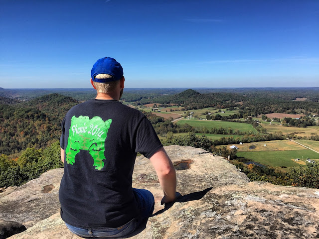
Luckily when the trail starts getting tougher we get some help. There are a couple of places that have rope and what appeared to be telephone cable to help you climb up the trail. Be careful and take your time in this section. Continue on up until you reach the summit. From here there is another split where you will turn right to climb down onto Carrington Rock. Once on the rock the view is spectacular. So sit down and catch your breath for a while. I would suggest to just take in the view for a while before you start taking pictures or playing with your phone. The view is better in person than through the viewfinder of a camera or on the screen of your phone. Take some time to appreciate it. I hope you all enjoyed my trip. Remember to get out there and explore. As they say "Life is either a daring adventure or nothing". Until next time thanks for your support.